It Just Gets Harder
- J. James Wheeling
- Jan 21
- 3 min read
In the last blog, I painted the picture of what an arduous trip the emigrants faced when they went west. Depending on where they started, whether it was Marietta, Ohio or Baltimore, MD, their route was relatively well known. Many used the Ohio River to the Mississippi River to get to St. Louis and then the Missouri River to St. Joseph, Missouri. They would have had steamers hauling their wagons, stock, and belongings. It would have been expensive, but they factored all of that into their trip.

But, once they reached their cross-country launching point, be it Independence or St. Joseph, they entered the toughest part of the trip. As discussed in earlier blogs, so many things were out of their control including disease, weather, accidents, and psychological breakdown.
There were also the geographic challenges. I thought I’d give you a picture of what they faced in terrain and obstacles. Rivers, deserts, mountains, cliffs, quicksand, gravel, mud, you name it, the 1849 emigrants faced it.
Once they left Independence or St. Joseph, they faced three major rivers: the North Platte, the Green, and the Humboldt. In many places along the California/Oregon Trail, the emigrants chose to move alongside the river but eventually they had to cross it. The Green River had a ferry at South Pass that was operated by Jim Bridger and Louis Vasquez. Otherwise, the wagon trains were on their own to ford the rivers.
Many, many diary accounts talk about the challenges of crossing rivers, especially when there was spring run-off or a thunderstorm that made the water swell over its banks. Accidents, including drownings of both animals and humans, occurred. Sometimes whole wagons had to be unloaded due to their weight and the difficulty it posed for a safe crossing. Women became very good at loading and unloading their belongings on a trip like this one.
They faced wide open plains and unforgiving deserts. Their first encounter with the wide expanse of the west would have been the Great Sand Hills in what is now Nebraska. Rolling hills of vast expanse of grass was mind-boggling to folks who were used to having a canopy of trees. Then they hit what we know today as the Red Desert (in modern Wyoming) followed by the Great Salt Desert (in modern Utah) and then the Great Basin (in modern Nevada).

Each of them was a dry, vast expanse of unforgiving openness. I can’t imagine what it had to have been like to see nothing of interest in all directions while being forced to cling to the hope that each day’s progress was getting closer to the goal.
And then there were the mountains. Up until the Sierra Nevada Mountain Range, the emigrants had encountered Continental Divide at South Pass but it is a relatively simple, sloping pass without the hazards of treacherous terrain. That all changed with the Sierra Nevada Mountains.
There were two main routes to summit the Sierras: Stephens Pass was renamed Donner Pass after the Donner-Reed Party’s tragic event in 1846-47. It runs just southwest of modern-day Reno, NV and drops into the Sacramento Valley. Known for heavy snow, it was a risk only those who timed their passing carefully dared to take. The Carson River Route was south of Lake Tahoe, and required only three river crossings and ended at Hangtown (modern Placerville) only ten miles from Sutter’s Mill where gold had been found.
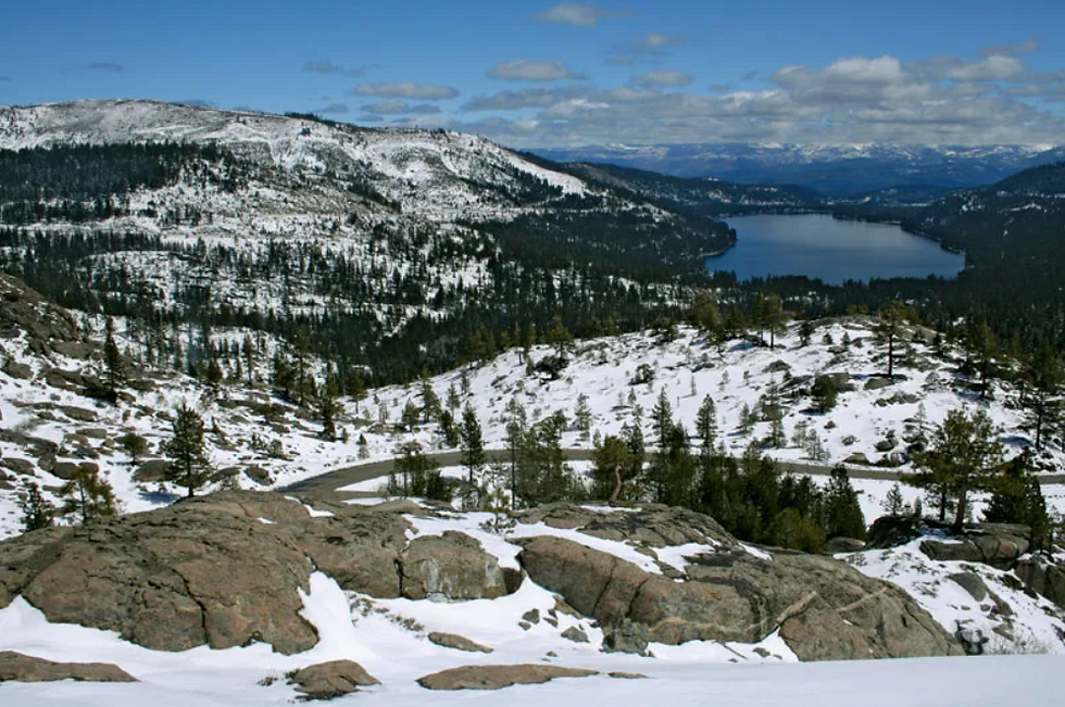
There were several other routes to both the north and south of these two, depending on the time of year and which goldfield (northern or southern) the emigrants were determined to get their start in. Whichever way they chose, crossing the Sierra Nevada Mountains was no easy thing. The trails were scratched out of the rock and livestock, already worn down from the desert crossing, struggled for footing and the strength to pull the wagons up and over the slippery stones. They had to cross rivers, boulder fields, and potentially, accumulated snowbanks from the previous winter. The women unloaded the wagons to lighten the loads for the animals and everyone pitched in to haul their belongings over the mountains.
In The Gantlet, Dash and his wagon company use the Carson Pass route to get to Hangtown and then on to Sacramento.
In my next blog, I will talk about the decisions the emigrants had to make when they did make it to California like which goldfield was right for them, northern or southern. Or what if hunting “easy riches” wasn’t their motivation at all? Mining the miners? What about women getting paid for domestic chores? Everything was a new opportunity in California.


Comments