The Many Trails to California
- J. James Wheeling
- Jan 1
- 3 min read
There were trails and then there were cutoffs.
Until I started my research, I, like many of us, assumed the Oregon Trail and the California Trail were kind of like our modern-day highways. Merge in and off you go! But, while many probably did just follow the wagon in front of them, the goldrush made folks do crazy stuff like find quicker ways to go around the masses in the name of speed. That’s where the idea of “cutoffs” came in. Here’s a little background.
Emigration to Oregon really started in 1836 when a wagon trail had been cleared from Independence, Missouri to Fort Hall, Idaho. When the trail was cleared to the Willamette Valley in Oregon, the trail was considered complete. The first wagon train originated in Independence, but it didn’t take long for starting points in Iowa, other parts of Missouri, and Nebraska Territory to become popular.

The Oregon Trail was most populated with emigrants from 1846 to 1869 and was 2,170 miles long east-west. When the Mormons veered off at South Pass in 1847, that branch of the trail became known as the Mormon Trail ending in Salt Lake City. The California Trail used the eastern half of the Oregon Trail to Fort Bridger and then Fort Hall before splitting and heading southwest across the Great Basin toward California. There were many cutoffs and branches that were created, some as time savers, others as ways to find feed for the wagon train’s livestock. Some worked, others were disasters.
Particularly interesting cutoffs were the Hastings Cutoff, the Sublette Cutoff and the Salt Lake Cutoff.
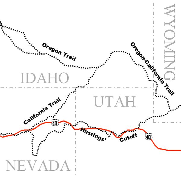
The Hastings Cutoff routed the emigrants from Fort Bridger to the south through the Wasatch Mountain Range, west across the Great Salt Lake Desert (nearly 80 miles of salt flats and waterless country), before looping northwest around the Ruby Mountains to rejoin the California Trail west of modern-day Elko, Nevada. One of the more famous groups to use this route is the ill-fated Donner Party and their misfortunes rose from a rather lackadaisical attitude toward getting down the trail. That all came back to haunt them in the Sierra Mountains.

The Sublette Cutoff branched off the main Oregon Trail at South Pass and was given the title, “Parting of the Ways.” To save time, it bypassed Fort Bridger and went directly west, over the mountains and to Bear River. The drawback was that it meant 50 miles with no water and limited grass for the livestock. It was popular because it saved time, but it required careful planning.

The Salt Lake Cutoff was created when Samuel Hensley tried to take the Hastings cutoff in 1848 but because of heavy rains, the route over the salt flats was too soft for wagon travel. So, he blazed a new trail that ran northwest out of Salt Lake City and joined the California Trail near City of Rocks, Idaho. This cutoff allowed emigrants to stop in Salt Lake City for provisions, repairs and fresh livestock.
In The Gantlet, I use a dare-I-say, unknown cutoff. I don’t recall when it came to me, in a book, a diary, or other resource material, but when I asked an old Wyoming rancher about it, he brightened and said, “Yes! We use that trail to move our cattle to summer pasture!” After we conferred with old maps a bit, I knew I had a unique and interesting twist for my story.

Some of this “cutoff” is on a National Geographic map described as the “Cherokee Trail.” The rest is from my old cowboy friend. It starts at Fort Laramie but instead of headed west and north on the California Trail, it goes south and west along the Medicine Bow Mountains before cutting through to the vast, and dry, most southern part of the valley we know now as the Red Desert in Wyoming. Highway 80 runs through this desert between Fort Bridger and Cheyenne.
In my next blog, I’m going to talk about the risks emigrants took and what happened when their luck ran out.


Comments